Bushkill Creek Monitoring Station
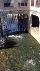
The Department of Geology, with the Civil Engineering Department, and the Environmental Science program have a new tool in assessing the Bushkill Creek. With the help of Stroud Water Research Center, a stream monitoring station has been installed. Initial installation was this summer, but a few electrical gremlins affected the water depth measurements. These gremlins have been removed, and the system is operating at full capacity. You can see the live data at the following site: http://monitormywatershed.org/sites/ULBC3S/
Other sites around the US can be found on this web application: http://monitormywatershed.org/browse/
What will we do with this data? Scientists will be able to monitor stream flow along the creek, and see the effect of storms on the flow of the creek. In addition to water depth, which is correlated into a flow volume, the site is monitoring temperature of the water, conductivity of the water, and turbidity of the water. The site is powered by a solar panel, and reports its data over a cell connection.